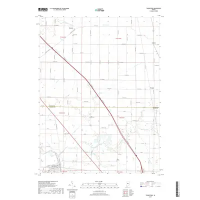
2019 Map of Thorntown
USGS Topo · Published 2019About this map
Thorntown serves as the primary hub in this portion of Boone County, situated along the southern edge of a landscape defined by its agricultural grid and winding waterways. The town's layout is grounded by Maple Lawn Cem and an Oxidation Pond at its western periphery, while the surrounding rural townships are dotted with historic burial grounds like Bethel Hill Cem and Gipson Cem. These small cemeteries often mark the sites of earlier family settlements or pioneer congregations that predated the consolidated rail and road networks of the 21st century.
Find a feature on this map
67 named features on this map. Tap any name to fly to it.
Don’t see what you’re looking for? This feature index may not catch every label — zoom into the map to look around manually.
Map Details
Editions of this 2019 Thorntown Map
This is the sole edition of this map. No revisions or reprints were ever made.
Other maps of this area

1953 · Lebanon
USGS Topo · 1:24,000

1953 · Danville
USGS Topo · 1:250,000

1955 · Danville
USGS Topo · 1:250,000

1956 · Danville
USGS Topo · 1:250,000

1961 · Michigantown
USGS Topo · 1:24,000

1961 · Mulberry
USGS Topo · 1:24,000

1961 · Mechanicsburg
USGS Topo · 1:24,000

1961 · Frankfort
USGS Topo · 1:24,000
1961 · Hazelrigg
USGS Topo · 1:24,000
1961 · Shannondale
USGS Topo · 1:24,000