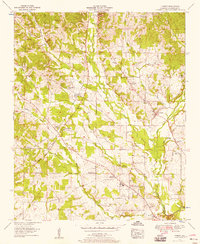
1954 Map of Threet
USGS Topo · Published 1958About this map
The Natchez Trace Parkway cuts through this rural landscape of northern Lauderdale County, tracing a path through hills drained by Cypress Creek and Threet Creek. Small agrarian communities are anchored by numerous country churches and schools, such as Hendricks Chapel, Salem Ch, and the Cloverdale School. The settlement at Threet sits near the headwaters of its namesake creek, while Sullivan Crossroads and Central Heights serve as southern landmarks in the quadrangle. For genealogists, several family-named landmarks and burial sites are documented, including Dowdy Cem, Austin Cem, and Simmons Cem. The terrain is characterized by a dense network of small branches and forks, such as Bruton Branch and Fowler Branch, which feed into the larger creek systems that eventually reach the Tennessee River valley.
Find a feature on this map
39 named features on this map. Tap any name to fly to it.
Don’t see what you’re looking for? This feature index may not catch every label — zoom into the map to look around manually.
Map Details
Editions of this 1954 Threet Map
4 editions found
Other maps of this area

1905 · Waynesboro
USGS Topo · 1:125,000

1914 · Muscle Shoals
USGS Topo · 1:48,000

1916 · Muscle Shoals
USGS Topo · 1:62,500

1924 · Gravelly Springs
USGS Topo · 1:48,000

1926 · Gravelly Springs
USGS Topo · 1:62,500

1935 · Cherokee
USGS Topo · 1:24,000

1935 · Wright
USGS Topo · 1:24,000

1936 · Light
USGS Topo · 1:24,000

1936 · Threet
USGS Topo · 1:24,000

1936 · Cypress Inn
USGS Topo · 1:24,000