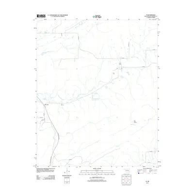
2012 Map of Ti
USGS Topo · Published 2012About this map
Ti Valley and the small settlement of Ti characterize this portion of Pittsburg County, where the landscape is defined by a dense network of creek drainages and intermittent streams. The terrain shifts from the narrow corridor of Oil Well Hollow to the broader basins of Rock Creek and Buck Creek. This area illustrates a rural Oklahoma pattern of small, dispersed communities centered around geographic features and family burial grounds, including Pine Top Cemetery and Lewis Cemetery.
Find a feature on this map
32 named features on this map. Tap any name to fly to it.
Don’t see what you’re looking for? This feature index may not catch every label — zoom into the map to look around manually.
Map Details
Editions of this 2012 Ti Map
This is the sole edition of this map. No revisions or reprints were ever made.
Other maps of this area

1898 · McAlester
USGS Topo · 1:125,000

1909 · Mc Alester
USGS Topo · 1:125,000

1950 · Mcalester
USGS Topo · 1:250,000

1962 · McAlester
USGS Topo · 1:250,000

1965 · McAlester
USGS Topo · 1:250,000

1967 · Pittsburg
USGS Topo · 1:24,000

1967 · Hartshorne SW
USGS Topo · 1:24,000
1967 · Savanna
USGS Topo · 1:24,000

1967 · Hartshorne
USGS Topo · 1:24,000
1973 · Adel
USGS Topo · 1:24,000