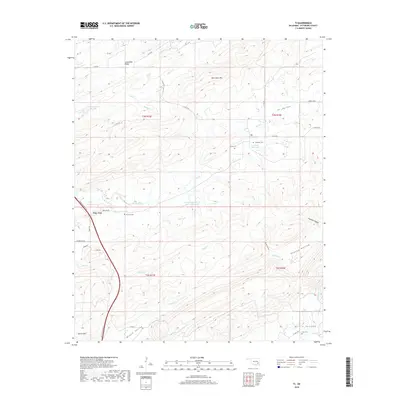
2018 Map of Ti
USGS Topo · Published 2018About this map
Ti and Pine Top sit within the complex ridgelines of Pittsburg County, where the southern Oklahoma landscape is defined by alternating high ridges and narrow agricultural valleys. The topography is dominated by Limestone Ridge to the north and the prominent New State Mtn and Hewitt Mtn, which frame a series of lowlands including Ti Valley, McGee Valley, and Burris Valley. This map illustrates a rural settlement pattern where life is oriented around these natural corridors and small water sources like Elm Cr and Rock Cr. Genealogists will find significant local value in the distribution of family and community burial grounds, including Ti Valley Cem, Lewis Cem, Pine Top Cem, and Clay Cem. The modern transit corridor of the Indian Nation Tpke cuts through the western portion of the quadrangle, contrasting with the older network of county roads like Ti Valley Rd and Burns Loop that follow the natural contours of the terrain.
Find a feature on this map
46 named features on this map. Tap any name to fly to it.
Don’t see what you’re looking for? This feature index may not catch every label — zoom into the map to look around manually.
Map Details
Editions of this 2018 Ti Map
This is the sole edition of this map. No revisions or reprints were ever made.
Other maps of this area

1898 · McAlester
USGS Topo · 1:125,000

1909 · Mc Alester
USGS Topo · 1:125,000

1950 · Mcalester
USGS Topo · 1:250,000

1962 · McAlester
USGS Topo · 1:250,000

1965 · McAlester
USGS Topo · 1:250,000

1967 · Pittsburg
USGS Topo · 1:24,000

1967 · Hartshorne SW
USGS Topo · 1:24,000
1967 · Savanna
USGS Topo · 1:24,000

1967 · Hartshorne
USGS Topo · 1:24,000
1973 · Adel
USGS Topo · 1:24,000