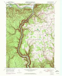
1946 Map of Tiadaghton
USGS Topo · Published 1972About this map
Pine Creek Gorge dominates this landscape, where the waters of Pine Creek carve a deep path through the high plateaus of Tioga County. This mid-century survey captures the region's complex network of small settlements and rural infrastructure before modernization altered the character of the valley. Narrow hamlets like Tiadaghton and Ansonia are oriented along the water and the Penn Central rail line, which tracks the river's edge.
Find a feature on this map
57 named features on this map. Tap any name to fly to it.
Don’t see what you’re looking for? This feature index may not catch every label — zoom into the map to look around manually.
Map Details
Editions of this 1946 Tiadaghton Map
5 editions found
Other maps of this area

1899 · Gaines
USGS Topo · 1:62,500

1900 · Gaines
USGS Topo · 1:62,500

1900 · Elkland
USGS Topo · 1:62,500

1946 · Tiadaghton
USGS Topo · 1:24,000

1946 · Antrim
USGS Topo · 1:62,500

1946 · Cedar Run
USGS Topo · 1:24,000

1946 · Antrim
USGS Topo · 1:24,000

1946 · Morris
USGS Topo · 1:24,000

1947 · Galeton
USGS Topo · 1:62,500

1947 · Lee Fire Tower
USGS Topo · 1:24,000
Featured Places
- Morris Township, PA
- Gaines Township, PA
- Tiadaghton, Delmar Township
- Delmar Township, PA
- Elk Township, PA