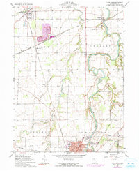
1960 Map of Tiffin North
USGS Topo · Published 1991About this map
The Sandusky River winds southward through this 1960 topographic survey, connecting the villages and agricultural townships of central Seneca County. Significant industrial activity is evident at Maple Grove, where a large Quarry and processing site sit at the junction of the Norfolk and Western and Penn Central railroads. The map documents a landscape defined by traditional rural institutions, including Hopewell Ch and Shiloh Ch, alongside mid-century additions like the Drive-in Theater near Fort Seneca. Local genealogy is well-supported by numerous burial grounds such as Feaselburg Cem and Fraver Cem. An interesting historical layer is the Indian Treaty Boundary, which cuts diagonally across the northern townships, preserving a vestige of early territorial divisions amid the grid of modern section lines and roads like Maule Road.
Find a feature on this map
45 named features on this map. Tap any name to fly to it.
Don’t see what you’re looking for? This feature index may not catch every label — zoom into the map to look around manually.
Map Details
Editions of this 1960 Tiffin North Map
Other maps of this area

1901 · Fostoria
USGS Topo · 1:62,500

1901 · Fremont
USGS Topo · 1:62,500

1901 · Elmore
USGS Topo · 1:62,500

1903 · Fremont
USGS Topo · 1:62,500

1903 · Fostoria
USGS Topo · 1:62,500

1903 · Elmore
USGS Topo · 1:62,500

1906 · Tiffin
USGS Topo · 1:62,500

1956 · Toledo
USGS Topo · 1:250,000

1958 · Fremont West
USGS Topo · 1:24,000
1958 · Fremont East
USGS Topo · 1:24,000