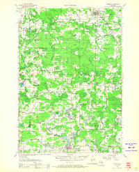
1955 Map of Tigerton
USGS Topo · Published 1966About this map
Tigerton and the winding course of the Embarrass River anchor this mid-century look at central Wisconsin. The landscape is defined by its water and woods, with the Chicago and North Western railway cutting through the northern townships of Germania and Fairbanks. Local life centers around a network of country schools and small settlements, many of which carry the names of Scandinavian and German settlers who established these communities. Notable landmarks like the Tigerton Lookout Tower and the Alban Chapel provide specific points of reference for local historians.
Find a feature on this map
73 named features on this map. Tap any name to fly to it.
Don’t see what you’re looking for? This feature index may not catch every label — zoom into the map to look around manually.
Map Details
Editions of this 1955 Tigerton Map
2 editions found
Other maps of this area

1899 · Wausau
USGS Topo · 1:125,000

1902 · Wausau
USGS Topo · 1:125,000

1953 · Hatley
USGS Topo · 1:48,000

1954 · Wittenberg
USGS Topo · 1:48,000

1954 · Gresham
USGS Topo · 1:48,000

1955 · Clintonville
USGS Topo · 1:48,000

1955 · Tigerton
USGS Topo · 1:48,000

1955 · Rosholt
USGS Topo · 1:48,000

1955 · Green Bay
USGS Topo · 1:250,000

1956 · Weyauwega
USGS Topo · 1:48,000