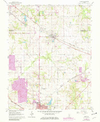
1965 Map of Tilden
USGS Topo · Published 1982About this map
The northern edge of Sparta and the rail-oriented villages of Tilden and Clarmin anchor this mid-1960s landscape, which was later updated to show the expansion of industrial activity in the early 1980s. The region is defined by a convergence of transportation and extraction, where the Illinois Central Gulf and Missouri Pacific railroads cross the agricultural terrain. A massive Strip Mine and an extensive Elevated Conveyor system underscore the area's significance in the Illinois coal basin, showing how industrial infrastructure integrated with local topography.
Find a feature on this map
29 named features on this map. Tap any name to fly to it.
Don’t see what you’re looking for? This feature index may not catch every label — zoom into the map to look around manually.
Map Details
Editions of this 1965 Tilden Map
2 editions found
Other maps of this area

1910 · Okawville
USGS Topo · 1:62,500

1912 · New Athens
USGS Topo · 1:62,500

1912 · Baldwin
USGS Topo · 1:62,500

1914 · Baldwin
USGS Topo · 1:62,500

1914 · Coulterville
USGS Topo · 1:62,500

1917 · Coulterville
USGS Topo · 1:62,500

1940 · Okawville
USGS Topo · 1:62,500

1942 · Baldwin
USGS Topo · 1:62,500
1954 · New Athens East
USGS Topo · 1:24,000
1954 · New Athens
USGS Topo · 1:62,500