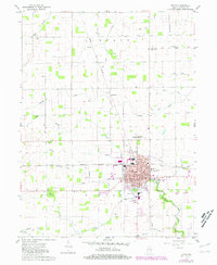
1960 Map of Tipton
USGS Topo · Published 1981About this map
Tipton serves as the central hub of this Indiana landscape, where a dense grid of streets like Adams Street and Harrison Street surrounds the downtown Courthouse. The town's growth is tied to the Norfolk and Western rail lines that intersect the urban center, supporting local institutions like Lincoln Sch and the County Hospital. Beyond the city limits, the terrain is defined by a sophisticated network of agricultural drainage, including the Treaty Ditch and Leavell Ditch, which manage the waters of Cicero Creek and Turkey Creek. This 1960s-era survey, updated in the late 1970s, captures the rural character of Liberty and Cicero townships. Scattered family-named landmarks and historical sites dot the countryside, from the St Joseph Academy and its associated St Joseph Academy Cem to smaller settlements like Mauldentown and Jacksons.
Find a feature on this map
65 named features on this map. Tap any name to fly to it.
Don’t see what you’re looking for? This feature index may not catch every label — zoom into the map to look around manually.
Map Details
Editions of this 1960 Tipton Map
2 editions found
Other maps of this area

1953 · Danville
USGS Topo · 1:250,000

1953 · Muncie
USGS Topo · 1:250,000

1955 · Danville
USGS Topo · 1:250,000

1956 · Muncie
USGS Topo · 1:250,000

1956 · Danville
USGS Topo · 1:250,000

1960 · Kokomo West
USGS Topo · 1:24,000

1960 · Kokomo East
USGS Topo · 1:24,000

1960 · Kempton
USGS Topo · 1:24,000

1960 · Tipton
USGS Topo · 1:24,000

1960 · Windfall
USGS Topo · 1:24,000