
1960 Map of Tipton
USGS Topo · Published 1961About this map
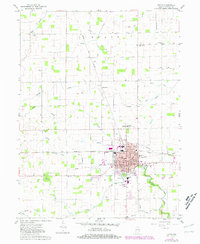
The street grid of Tipton serves as the focal point of this Central Indiana landscape at the start of the 1960s, showing a well-defined urban core anchored by the Courthouse and Armory. The city's growth is traced through its educational and civic institutions, from St Joseph Academy to the County Hospital and County Home. Surrounding the settlement, the New York Chicago and St Louis Railroad cuts a diagonal path through the countryside, facilitating the movement of goods in this agricultural region.
Find a feature on this map
60 named features on this map. Tap any name to fly to it.
Don’t see what you’re looking for? This feature index may not catch every label — zoom into the map to look around manually.
Map Details
Editions of this 1960 Tipton Map
2 editions found
Other maps of this area

1953 · Danville
USGS Topo · 1:250,000

1953 · Muncie
USGS Topo · 1:250,000

1955 · Danville
USGS Topo · 1:250,000

1956 · Muncie
USGS Topo · 1:250,000

1956 · Danville
USGS Topo · 1:250,000

1960 · Kokomo West
USGS Topo · 1:24,000

1960 · Kokomo East
USGS Topo · 1:24,000

1960 · Kempton
USGS Topo · 1:24,000

1960 · Windfall
USGS Topo · 1:24,000

1960 · Greentown
USGS Topo · 1:24,000