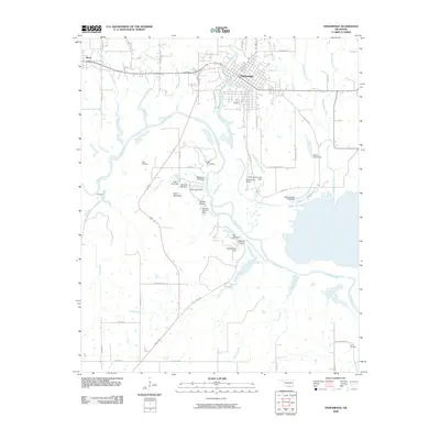
2009 Map of Tishomingo
USGS Topo · Published 2009About this map
Tishomingo serves as the focal point of this Johnston County landscape, situated where Pennington Creek flows toward the sweeping curves of the Washita River. The terrain is defined by a dense network of water management features, including numerous small impoundments such as Teal Pond Dam, McAdams Pond Dam, and Muel Lake Dam. These structures, along with larger bodies like Cottonwood Lake, illustrate the regional reliance on surface water control for ranching and local utility. To the west, the community of Ravia sits near the headwaters of Sand Creek, while the southern reaches are marked by the presence of Linn Cemetery and the isolated settlement of Randolph.
Find a feature on this map
57 named features on this map. Tap any name to fly to it.
Don’t see what you’re looking for? This feature index may not catch every label — zoom into the map to look around manually.
Map Details
Editions of this 2009 Tishomingo Map
This is the sole edition of this map. No revisions or reprints were ever made.
Other maps of this area

1901 · Tishomingo
USGS Topo · 1:125,000

1957 · Ardmore
USGS Topo · 1:250,000

1963 · Ardmore
USGS Topo · 1:250,000

1963 · Madill
USGS Topo · 1:24,000

1963 · Troy
USGS Topo · 1:24,000

1963 · Ravia
USGS Topo · 1:24,000
1967 · Tishomingo SW
USGS Topo · 1:24,000

1967 · Connerville SE
USGS Topo · 1:24,000

1967 · Tishomingo
USGS Topo · 1:24,000
1967 · Reagan
USGS Topo · 1:24,000