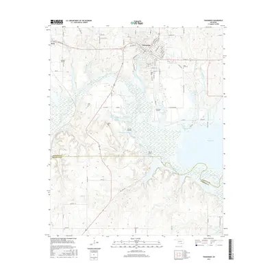
2016 Map of Tishomingo
USGS Topo · Published 2016About this map
Tishomingo and the neighboring settlement of Ravia anchor this southern Oklahoma landscape where the Washita River meets the northern reaches of Lake Texoma. As the Johnston County seat, Tishomingo is characterized by its organized street grid and the central campus of Murray State Coll. The terrain is shaped by numerous water bodies and small-scale water management, including Whiskey Creek Reservoir, Reeves Ravine Reservoir, and Cottonwood Lake.
Find a feature on this map
90 named features on this map. Tap any name to fly to it.
Don’t see what you’re looking for? This feature index may not catch every label — zoom into the map to look around manually.
Map Details
Editions of this 2016 Tishomingo Map
This is the sole edition of this map. No revisions or reprints were ever made.
Other maps of this area

1901 · Tishomingo
USGS Topo · 1:125,000

1957 · Ardmore
USGS Topo · 1:250,000

1963 · Ardmore
USGS Topo · 1:250,000

1963 · Madill
USGS Topo · 1:24,000

1963 · Troy
USGS Topo · 1:24,000

1963 · Ravia
USGS Topo · 1:24,000
1967 · Tishomingo SW
USGS Topo · 1:24,000

1967 · Connerville SE
USGS Topo · 1:24,000

1967 · Tishomingo
USGS Topo · 1:24,000
1967 · Reagan
USGS Topo · 1:24,000