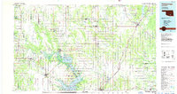
1985 Map of Tishomingo
USGS Topo · Published 1986About this map
The Washita River and the Blue River systems dominate this mid-1980s landscape, converging toward the sprawling waters of Lake Texoma. The map captures a significant concentration of conservation and wildlife management areas, including the Tishomingo National Wildlife Refuge and the Tishomingo Nat Fish Hatchery north of Emet. In the east, the Atoka Reservoir and Muddy Boggy Creek define the geography near Atoka and Stringtown.
Find a feature on this map
102 named features on this map. Tap any name to fly to it.
Don’t see what you’re looking for? This feature index may not catch every label — zoom into the map to look around manually.
Map Details
Editions of this 1985 Tishomingo Map
3 editions found
Other maps of this area

1896 · Coalgate
USGS Topo · 1:125,000

1898 · McAlester
USGS Topo · 1:125,000

1898 · Pauls Valley
USGS Topo · 1:125,000

1899 · Coalgate
USGS Topo · 1:125,000

1899 · Atoka
USGS Topo · 1:125,000

1900 · Atoka
USGS Topo · 1:125,000

1900 · Coalgate
USGS Topo · 1:125,000

1901 · Stonewall
USGS Topo · 1:125,000

1901 · Tishomingo
USGS Topo · 1:125,000

1901 · Antlers
USGS Topo · 1:125,000