1952 Map of Tivoli SE
USGS Topo · Published 1987About this map
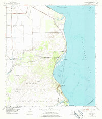
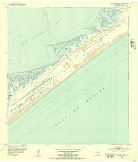
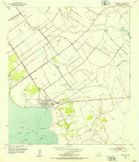
The Blackjack Peninsula serves as the dominant landform of this coastal Texas region, situated at the confluence of Hynes Bay and San Antonio Bay. Much of the landscape is preserved as part of the Aransas National Wildlife Refuge, where the Refuge Headquarters is located near the eastern shore. The coastal margin is defined by distinct landmarks such as McDowell Point, Webb Point, and Dagger Point, alongside unique topographical features like The Sand Mounds.
Find a feature on this map
29 named features on this map. Tap any name to fly to it.
Don’t see what you’re looking for? This feature index may not catch every label — zoom into the map to look around manually.
Map Details
Editions of this 1952 Tivoli SE Map
2 editions found
Other maps of this area
1952 · Mosquito Point
USGS Topo · 1:24,000
1952 · St. Charles Bay
USGS Topo · 1:24,000
1952 · Tivoli
USGS Topo · 1:24,000
1952 · Mesquite Bay
USGS Topo · 1:24,000
1952 · Tivoli SE
USGS Topo · 1:24,000
1952 · Panther Point
USGS Topo · 1:24,000
1952 · Austwell
USGS Topo · 1:24,000
1952 · Seadrift
USGS Topo · 1:24,000
1952 · Tivoli SW
USGS Topo · 1:24,000

1953 · Beeville
USGS Topo · 1:250,000