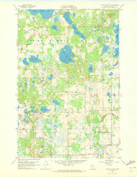
1959 Map of Toad Mountain
USGS Topo · Published 1973About this map
Height of Land and the surrounding Becker County wilderness define this 1950s landscape, where glacial activity left behind a dense network of lakes and marshes. The northern portion is dominated by the massive Height of Land Lake and the prominent Toad Mountain, while the southern reaches are drained by Dead Horse Creek and Colette Creek. This period shows a quiet, rural infrastructure concentrated in the townships of Silver Leaf and Evergreen. Local social centers are anchored by landmarks like St Johns Ch and St Pauls Ch, alongside the community Town Hall. The map traces a transitional landscape between the open waters of Little Toad Lake and the thick forests that characterize this portion of the Minnesota lake country, reflecting a time before significant modern development altered these remote shorelines.
Find a feature on this map
25 named features on this map. Tap any name to fly to it.
Don’t see what you’re looking for? This feature index may not catch every label — zoom into the map to look around manually.
Map Details
Editions of this 1959 Toad Mountain Map
3 editions found
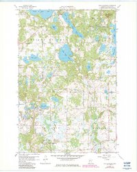
Other maps of this area

1915 · Perham
USGS Topo · 1:62,500

1953 · Brainerd
USGS Topo · 1:250,000

1957 · Brainerd
USGS Topo · 1:250,000

1958 · Brainerd
USGS Topo · 1:250,000

1959 · Toad Mountain
USGS Topo · 1:24,000

1959 · Flat Lake
USGS Topo · 1:24,000

1959 · Rochert
USGS Topo · 1:24,000

1959 · Height Of Land Lake
USGS Topo · 1:24,000

1965 · Brainerd
USGS Topo · 1:250,000

1969 · Evergreen
USGS Topo · 1:24,000