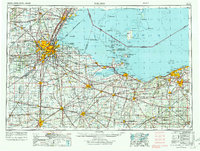
1956 Map of Toledo
USGS Topo · Published 1972About this map
Toledo serves as the industrial and transit hub of this Western Lake Erie survey, situated where the Maumee River meets Maumee Bay. The 1969 revision captures the region's mid-century infrastructure, dominated by an extensive rail network including the New York Central RR and the Nickel Plate Road, which link major manufacturing centers like Fremont, Tiffin, and Findlay. Along the shoreline, the map details the recreation and military landscape of the era, from the training grounds at Camp Perry to the island clusters of Pelee Island, South Bass Island, and Kelleys Island. This edition documents the expanding Ohio Turnpike as it cuts across the agricultural interior, connecting the lakefront cities with inland hubs like Norwalk and Fostoria. The intricate hydrology of the Sandusky River and Portage River systems illustrates the drainage patterns that defined the development of Northwest Ohio's lowland plains.
Find a feature on this map
242 named features on this map. Tap any name to fly to it.
Don’t see what you’re looking for? This feature index may not catch every label — zoom into the map to look around manually.
Map Details
Editions of this 1956 Toledo Map
4 editions found

Other maps of this area

1900 · Maumee Bay
USGS Topo · 1:62,500

1900 · Toledo
USGS Topo · 1:62,500

1900 · Oak Harbor
USGS Topo · 1:62,500

1901 · Oberlin
USGS Topo · 1:62,500

1901 · Put-In-Bay
USGS Topo · 1:62,500

1901 · Bellevue
USGS Topo · 1:62,500

1901 · Fostoria
USGS Topo · 1:62,500

1901 · Bowling Green
USGS Topo · 1:62,500

1901 · Fremont
USGS Topo · 1:62,500

1901 · Wooster
USGS Topo · 1:62,500