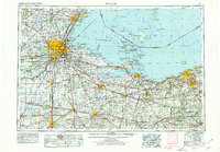
1956 Map of Toledo
USGS Topo · Published 1979About this map
The industrial and maritime corridors of Northwest Ohio and the Lake Erie islands define this mid-century landscape. Following the Ohio Turnpike and an extensive rail network including the Pennsylvania RR and New York Central RR, the map illustrates a region anchored by Toledo and Sandusky. The importance of Lake Erie commerce is evident through landmarks like Toledo Harbor Light and Marblehead Light, while the interior shows the agricultural and industrial hubs of Findlay, Fostoria, and Fremont.
Find a feature on this map
489 named features on this map. Tap any name to fly to it.
Don’t see what you’re looking for? This feature index may not catch every label — zoom into the map to look around manually.
Map Details
Editions of this 1956 Toledo Map
4 editions found

Other maps of this area

1900 · Maumee Bay
USGS Topo · 1:62,500

1900 · Toledo
USGS Topo · 1:62,500

1900 · Oak Harbor
USGS Topo · 1:62,500

1901 · Oberlin
USGS Topo · 1:62,500

1901 · Put-In-Bay
USGS Topo · 1:62,500

1901 · Bellevue
USGS Topo · 1:62,500

1901 · Fostoria
USGS Topo · 1:62,500

1901 · Bowling Green
USGS Topo · 1:62,500

1901 · Fremont
USGS Topo · 1:62,500

1901 · Wooster
USGS Topo · 1:62,500