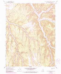
1966 Map of Tom Patterson Canyon
USGS Topo · Published 1987About this map
Mc Cook Ridge and its long fingers define the high Uintah County plateau, carved by the branching drainage of Tom Patterson Canyon. This 1966 field-checked landscape, later updated in 1987, reveals a network of water sources vital to high-altitude transit, including Sweet Water Spring and Black Horse Spring. The terrain is marked by historical movement along the Moccasin Trail and Taylor Canyon Trail, suggesting established paths through the complex canyon system. The existence of a Landing Strip on West Tom Patterson Point indicates the mid-century's reach into these remote reaches for resource management or surveying. To the east, Bitter Creek flows northward, flanked by prominent landforms like Rat Hole Ridge and August Canyon, while the Colorado state line lies just a few miles away across the high-desert divide.
Find a feature on this map
27 named features on this map. Tap any name to fly to it.
Don’t see what you’re looking for? This feature index may not catch every label — zoom into the map to look around manually.
Map Details
Editions of this 1966 Tom Patterson Canyon Map
2 editions found
Other maps of this area

1885 · East Tavaputs
USGS Topo · 1:250,000

1956 · Grand Junction
USGS Topo · 1:250,000

1959 · Grand Junction
USGS Topo · 1:250,000

1960 · Grand Junction
USGS Topo · 1:250,000

1962 · Grand Junction
USGS Topo · 1:250,000

1964 · Grand Junction
USGS Topo · 1:250,000

1965 · Grand Junction
USGS Topo · 1:250,000

1966 · Seep Canyon
USGS Topo · 1:24,000

1966 · Tom Patterson Canyon
USGS Topo · 1:24,000
1966 · Rat Hole Ridge
USGS Topo · 1:24,000