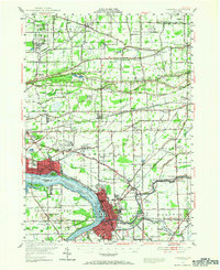
1948 Map of Tonawanda
USGS Topo · Published 1966About this map
The Tuscarora Indian Reservation and the industrial corridors of the Niagara River define this 1940s-era landscape. The map illustrates a complex network of transportation and water management, where the Erie Canal flows toward the Niagara River Tonawanda Channel. Settlement patterns follow the distinct elevation changes of Ridge Road, Upper Mountain Road, and Lower Mountain Road, which separate the agricultural lowlands of Porter Center and Ransomville from the higher terrain. Aviation history is prominent with the Niagara Falls Municipal Airport and smaller fields like Shawnee Airport and County Line Airport. Local genealogy is well-represented through dozens of numbered school districts and family-named cemeteries, including Bear Ridge Cem and the expansive White Chapel Memorial Cemetery, reflecting the dense communal history of Erie and Niagara counties during this post-war period.
Find a feature on this map
125 named features on this map. Tap any name to fly to it.
Don’t see what you’re looking for? This feature index may not catch every label — zoom into the map to look around manually.
Map Details
Editions of this 1948 Tonawanda Map
3 editions found
Other maps of this area

1894 · Buffalo
USGS Topo · 1:62,500

1894 · Niagara Falls
USGS Topo · 1:62,500

1894 · Wilson
USGS Topo · 1:62,500

1896 · Niagara Falls
USGS Topo · 1:62,500

1897 · Tonawanda
USGS Topo · 1:62,500

1897 · Olcott
USGS Topo · 1:62,500

1897 · Lockport
USGS Topo · 1:62,500

1899 · Niagara
USGS Topo · 1:125,000

1900 · Wilson
USGS Topo · 1:62,500

1900 · Tonawanda
USGS Topo · 1:62,500