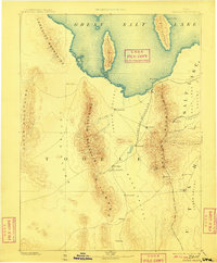
1885 Map of Tooele Valley
USGS Topo · Published 1908About this map
Tooele and its surrounding mountain ranges dominate this late 19th-century reconnaissance, which captures the industrial and agricultural expansion across north-central Utah. The map reveals a landscape defined by sharp elevation changes, where the Oquirrh Mountains and Stansbury Mountains separate high-desert basins like Skull Valley and Rush Valley. Mining interest is evident in the cluster of settlements along the eastern slopes, including Bingham and Ophir, while the northern portion of the sheet is anchored by the southern reaches of the Great Salt Lake. Transportation of the era is represented by the Utah and Nevada R. R., which links Lake Point to Stockton. Smaller outposts such as Fausts and Vernon mark the southern interior, illustrating the sparse but deliberate settlement patterns characteristic of the Great Basin prior to modern development.
Find a feature on this map
37 named features on this map. Tap any name to fly to it.
Don’t see what you’re looking for? This feature index may not catch every label — zoom into the map to look around manually.
Map Details
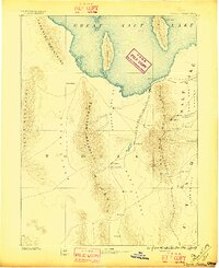
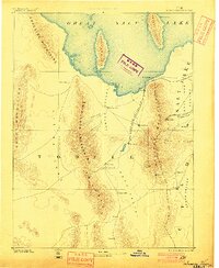
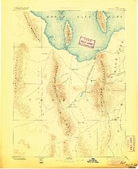
Editions of this 1885 Tooele Valley Map
6 editions found

Other maps of this area

1885 · Salt Lake
USGS Topo · 1:250,000

1885 · Manti
USGS Topo · 1:250,000

1885 · Sevier Desert
USGS Topo · 1:250,000

1885 · Tooele Valley
USGS Topo · 1:250,000

1895 · Manti
USGS Topo · 1:250,000

1908 · Fish Springs
USGS Topo · 1:250,000

1910 · Fish Springs
USGS Topo · 1:250,000

1915 · Fairfield
USGS Topo · 1:62,500

1917 · Fairfield
USGS Topo · 1:62,500

1918 · Stockton
USGS Topo · 1:62,500