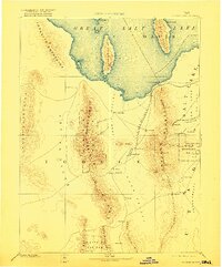
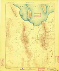
1885 Map of Tooele Valley
USGS Topo · Published 1922About this map
Tooele and the surrounding basin are shown here in a late 19th-century reconnaissance survey that captures the early development of western Utah. The landscape is dominated by the southern reaches of the Great Salt Lake, with Stansbury Island and Antelope Island appearing as prominent landmasses within the water. Transport in the region is defined by the Utah and Nevada R. R., which skirts the shoreline near Lake Point before turning south toward the mining and agricultural centers of Stockton and St John.
Find a feature on this map
45 named features on this map. Tap any name to fly to it.
Don’t see what you’re looking for? This feature index may not catch every label — zoom into the map to look around manually.
Map Details
Editions of this 1885 Tooele Valley Map
6 editions found
Other maps of this area

1885 · Salt Lake
USGS Topo · 1:250,000

1885 · Manti
USGS Topo · 1:250,000

1885 · Sevier Desert
USGS Topo · 1:250,000

1885 · Tooele Valley
USGS Topo · 1:250,000

1895 · Manti
USGS Topo · 1:250,000

1908 · Fish Springs
USGS Topo · 1:250,000

1910 · Fish Springs
USGS Topo · 1:250,000

1915 · Fairfield
USGS Topo · 1:62,500

1917 · Fairfield
USGS Topo · 1:62,500

1918 · Stockton
USGS Topo · 1:62,500