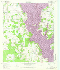
1960 Map of Tool
USGS Topo · Published 1973About this map
Cedar Creek Reservoir dominates this landscape, its expansive waters shown here in purple as a 1972 photorevision over the original 1960 topography. This period of rapid change is evident in the transition from traditional farming communities like Aley and Tolosa to emerging lakeside settlements such as Gun Barrel City and Tool. The map records the area just as it began transforming into a recreational and residential hub, while maintaining evidence of its older agrarian and industrial roots, including the Southern Pacific railroad line and the Flag Lake Oil Field to the southwest.
Find a feature on this map
27 named features on this map. Tap any name to fly to it.
Don’t see what you’re looking for? This feature index may not catch every label — zoom into the map to look around manually.
Map Details
Editions of this 1960 Tool Map
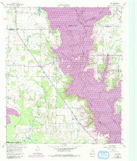
Other maps of this area

1920 · Kemp
USGS Topo · 1:62,500

1954 · Dallas
USGS Topo · 1:250,000

1957 · Kemp
USGS Topo · 1:62,500

1958 · Dallas
USGS Topo · 1:250,000

1960 · Tool
USGS Topo · 1:24,000

1960 · Mabank
USGS Topo · 1:24,000

1960 · Malakoff
USGS Topo · 1:24,000

1960 · Grays Prairie
USGS Topo · 1:24,000

1961 · Kemp
USGS Topo · 1:24,000

1961 · Kerens
USGS Topo · 1:24,000