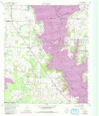
1960 Map of Tool
USGS Topo · Published 1981About this map
Cedar Creek Reservoir dominates the landscape of this East Texas survey, its sprawling waters reaching into the valleys of Lacy Fork and Persimmon Branch. Compiled from 1958 and 1960 data with 1981 revisions, the map captures a period of transition as lakeside developments like Gun Barrel City and Tool began to expand. South of these burgeoning settlements, the Flag Lake Oil Field indicates the region's industrial ties, marked by a network of pipelines and an aqueduct that cuts across the terrain toward the Trinity River.
Find a feature on this map
29 named features on this map. Tap any name to fly to it.
Don’t see what you’re looking for? This feature index may not catch every label — zoom into the map to look around manually.
Map Details
Editions of this 1960 Tool Map
Other maps of this area

1920 · Kemp
USGS Topo · 1:62,500

1954 · Dallas
USGS Topo · 1:250,000

1957 · Kemp
USGS Topo · 1:62,500

1958 · Dallas
USGS Topo · 1:250,000

1960 · Tool
USGS Topo · 1:24,000

1960 · Mabank
USGS Topo · 1:24,000

1960 · Malakoff
USGS Topo · 1:24,000

1960 · Grays Prairie
USGS Topo · 1:24,000

1961 · Kemp
USGS Topo · 1:24,000

1961 · Kerens
USGS Topo · 1:24,000