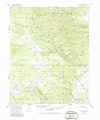
1956 Map of Tooth Of Time
USGS Topo · Published 1986About this map
Philmont Scout Ranch dominates this mid-century landscape, showcasing a complex network of camps and trails established within the Beaubien and Miranda Grant (Maxwell Grant). The map records the iconic geography of the Sangre de Cristo foothills, centered on the jagged profile of Tooth of Time along the Tooth of Time Ridge. The distribution of high-altitude camps like Cimarroncito Base Camp and Rayado Base Camp reflects the area's development for youth adventure and conservation.
Find a feature on this map
120 named features on this map. Tap any name to fly to it.
Don’t see what you’re looking for? This feature index may not catch every label — zoom into the map to look around manually.
Map Details
Editions of this 1956 Tooth Of Time Map
4 editions found
Other maps of this area

1954 · Raton
USGS Topo · 1:250,000

1955 · Cimarron
USGS Topo · 1:62,500

1955 · Ute Park
USGS Topo · 1:62,500

1956 · Tooth Of Time
USGS Topo · 1:62,500

1956 · Miami
USGS Topo · 1:62,500

1958 · Raton
USGS Topo · 1:250,000

1963 · Eagle Nest
USGS Topo · 1:24,000

1965 · Osha Mountain
USGS Topo · 1:24,000

1965 · Chacon
USGS Topo · 1:24,000

1965 · Palo Flechado Pass
USGS Topo · 1:24,000