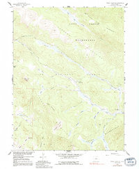
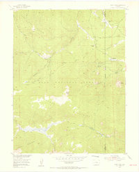
1958 Map of Topaz Mountain
USGS Topo · Published 1991About this map
The Kenosha Mountains and Lost Creek Wilderness dominate this high-altitude landscape in Park County, where the North Fork South Platte River carves a deep valley through the northern section of the Pike National Forest. This 1958 field-checked survey documents a period when the area was primarily used for resource extraction and seasonal grazing, as evidenced by the presence of the Northup Lumber Camp and Lost Park Cow Camp. Topographic interest centers on high summits like Topaz Mountain and North Tarryall Peak, alongside the striking recovery area of the Hourglass Burn. Access into this backcountry was facilitated by the Lost Park Road and historic paths like the Hooper Trail, connecting isolated water sources such as Bonis Spring and Cabin Spring across the rugged gulches and peaks.
Find a feature on this map
35 named features on this map. Tap any name to fly to it.
Don’t see what you’re looking for? This feature index may not catch every label — zoom into the map to look around manually.
Map Details
Editions of this 1958 Topaz Mountain Map
4 editions found
Other maps of this area

1893 · Platte Canyon
USGS Topo · 1:125,000

1945 · Bailey
USGS Topo · 1:24,000

1945 · Shawnee
USGS Topo · 1:24,000

1945 · Mount Logan
USGS Topo · 1:24,000

1948 · Mount Logan
USGS Topo · 1:24,000

1948 · Shawnee
USGS Topo · 1:24,000

1949 · Bailey
USGS Topo · 1:24,000

1953 · Denver
USGS Topo · 1:250,000
1954 · Windy Peak
USGS Topo · 1:24,000

1956 · Eagle Rock
USGS Topo · 1:24,000