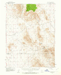
1953 Map of Topaz Mtn
USGS Topo · Published 1963About this map
Topaz Mountain and the surrounding high desert of the Drum Mountains define this mid-century landscape on the border of Juab and Millard Counties. Following fieldwork in the early 1950s, this survey documents a period of active mineral exploration across the Spor Mountain range, where small-scale extraction is evidenced by the Bell Hill Mine and Willden Mine. The arid terrain is punctuated by vital water sources like Schoenburger Spring and Laird Spring, which were essential for both the mining operations and local transit through the region. Transportation at the time relied on unimproved routes such as the Sand Pass Road and the Delta Callao Road, which skirted around landmarks like Eagle Rock Ridge and Antelope Ridge. To the south, the survey traces the slopes of Swasey Mountain and the Little Drum Mountains, identifying isolated features like the Ibis Mine and Black Boy Mine.
Find a feature on this map
27 named features on this map. Tap any name to fly to it.
Don’t see what you’re looking for? This feature index may not catch every label — zoom into the map to look around manually.
Map Details
Editions of this 1953 Topaz Mtn Map
4 editions found
Other maps of this area

1885 · Sevier Desert
USGS Topo · 1:250,000

1908 · Fish Springs
USGS Topo · 1:250,000

1910 · Fish Springs
USGS Topo · 1:250,000

1953 · Dugway Pass
USGS Topo · 1:24,000

1953 · Dugway Range
USGS Topo · 1:62,500

1953 · Topaz Mtn
USGS Topo · 1:62,500

1953 · Delta
USGS Topo · 1:250,000

1958 · Delta
USGS Topo · 1:250,000

1962 · Delta
USGS Topo · 1:250,000

1967 · Sand Pass SE
USGS Topo · 1:24,000