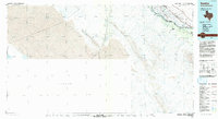
1985 Map of Tornillo
USGS Topo · Published 1993About this map
The Rio Grande serves as the focal point for this mid-1980s borderland study, defining the international boundary between El Paso County, Texas, and Mexico. The landscape is dominated by the agricultural and transit corridor northwest of the river, where the Southern Pacific railroad and Texas Road parallel the water. Settlements like Fabens, Tornillo, and Alamo Alto are tightly clustered near this vital infrastructure. A complex network of irrigation, including the Tornillo Canal, Alamo Canal, and Caseta Canal, illustrates the intensive water management required to support life and farming in this arid valley. Across the border, the map details the town of Guadalupe D. B. and the rugged peaks of the Sierra Del Presidio, providing a rare look at the cross-border terrain before modern development shifted the region's character.
Find a feature on this map
27 named features on this map. Tap any name to fly to it.
Don’t see what you’re looking for? This feature index may not catch every label — zoom into the map to look around manually.
Map Details
Editions of this 1985 Tornillo Map
2 editions found
Other maps of this area

1894 · Fort Hancock
USGS Topo · 1:125,000

1896 · El Paso
USGS Topo · 1:125,000

1896 · Rio Grande
USGS Topo · 1:125,000

1903 · Cerro Alto
USGS Topo · 1:125,000

1908 · El Paso
USGS Topo · 1:125,000

1939 · Ysleta
USGS Topo · 1:62,500

1941 · Clint
USGS Topo · 1:62,500

1941 · Ysleta
USGS Topo · 1:62,500

1941 · Tornillo
USGS Topo · 1:62,500

1942 · Borrego
USGS Topo · 1:62,500