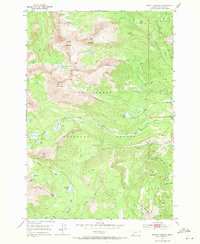
1952 Map of Torrey Mountain
USGS Topo · Published 1971About this map
The Pioneer Mountains dominate this high-altitude landscape within the Beaverhead National Forest, defined by a series of prominent peaks and glacial cirques. Elevation reaches its peak at Tweedy Mountain and Torrey Mountain, where the topography creates a dense network of alpine water bodies including the Gorge Lakes, Glacier Lake, and Torrey Lake. This environment supported a system of early infrastructure and resource extraction, evidenced by the scattered Mine symbols and the established Thief Creek Road and Birch Creek Road. The drainage patterns are intricate, with DuBois Creek, Birch Creek, and Thief Creek carving deep paths through the terrain. Numerous smaller basins hold named lakes such as Minneopa Lake and Boatman Lake, reflecting the geological complexity of the range before modern development altered these backcountry routes.
Find a feature on this map
49 named features on this map. Tap any name to fly to it.
Don’t see what you’re looking for? This feature index may not catch every label — zoom into the map to look around manually.
Map Details
Editions of this 1952 Torrey Mountain Map
5 editions found
Other maps of this area

1893 · Dillon
USGS Topo · 1:250,000

1952 · Twin Adams Mountain
USGS Topo · 1:24,000

1952 · Argenta
USGS Topo · 1:24,000

1952 · Torrey Mountain
USGS Topo · 1:24,000

1952 · Ermont
USGS Topo · 1:24,000

1955 · Dillon
USGS Topo · 1:250,000

1957 · Dillon
USGS Topo · 1:250,000

1958 · Dillon
USGS Topo · 1:250,000

1958 · Vipond Park
USGS Topo · 1:62,500

1959 · Polaris
USGS Topo · 1:62,500