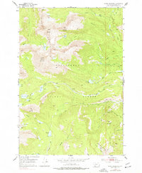
1952 Map of Torrey Mountain
USGS Topo · Published 1977About this map
Pioneer Mountains peaks dominate this high-altitude landscape within the Beaverhead National Forest, reaching their highest elevations at Tweedy Mountain and Torrey Mountain. This 1952 field-checked survey reveals an alpine environment carved by drainage systems like Buckhorn Creek and Birch Creek, which feed into numerous glacial basins. High-elevation water bodies such as Gorge Lakes, Barb Lake, and Torrey Lake are scattered across the peaks, while lower slopes show evidence of early access through the Thief Creek Road and various Foot Trails. A single Mine and the Winkley Camp signify the limited industrial and recreational footprint in this wilderness area, while Sawlog Gulch and Armstrong Gulch trace the steep descent of the terrain toward the valley floor.
Find a feature on this map
43 named features on this map. Tap any name to fly to it.
Don’t see what you’re looking for? This feature index may not catch every label — zoom into the map to look around manually.
Map Details
Editions of this 1952 Torrey Mountain Map
5 editions found
Other maps of this area

1893 · Dillon
USGS Topo · 1:250,000

1952 · Twin Adams Mountain
USGS Topo · 1:24,000

1952 · Argenta
USGS Topo · 1:24,000

1952 · Torrey Mountain
USGS Topo · 1:24,000

1952 · Ermont
USGS Topo · 1:24,000

1955 · Dillon
USGS Topo · 1:250,000

1957 · Dillon
USGS Topo · 1:250,000

1958 · Dillon
USGS Topo · 1:250,000

1958 · Vipond Park
USGS Topo · 1:62,500

1959 · Polaris
USGS Topo · 1:62,500