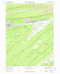
1969 Map of Tower City
USGS Topo · Published 1978About this map
The northern anthracite coal region defines the industrial character of this landscape, where the coal-rich mountains of Schuylkill and Dauphin counties converge. The settlements of Tower City and Williamstown follow the valley floor, while the surrounding slopes of Bear Mountain and Big Lick Mountain are marked by the extensive footprint of the extractive industry. Distinctive mining features, such as a large Mines Dump near Sheridan, underscore the area's economic foundations. To the south, the terrain shifts into protected wilderness, including large tracts of State Game Lands No 211 and State Forest. This transition from the industrial Wiconisco Creek valley to the ridge-top path of the Appalachian Trail highlights the complex land use of the era, balancing intensive resource extraction with burgeoning recreational spaces like Twin Grove Park.
Find a feature on this map
58 named features on this map. Tap any name to fly to it.
Don’t see what you’re looking for? This feature index may not catch every label — zoom into the map to look around manually.
Map Details
Editions of this 1969 Tower City Map
4 editions found
Other maps of this area

1891 · Lebanon
USGS Topo · 1:62,500

1892 · Lykens
USGS Topo · 1:62,500

1892 · Hummelstown
USGS Topo · 1:62,500

1892 · Pine Grove
USGS Topo · 1:62,500

1893 · Lykens
USGS Topo · 1:62,500

1893 · Lebanon
USGS Topo · 1:62,500

1899 · Lebanon
USGS Topo · 1:62,500

1924 · Hummelstown
USGS Topo · 1:62,500

1943 · Lebanon
USGS Topo · 1:62,500

1943 · Lykens
USGS Topo · 1:62,500
Featured Places
- Hegins Township, PA
- Williamstown, PA
- Tower City, Porter Township
- Jackson Township, PA
- Jefferson Township, PA