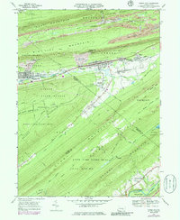
1969 Map of Tower City
USGS Topo · Published 1986About this map
Tower City and Williamstown anchor a landscape defined by the anthracite coal region's narrow valleys and steep ridges during the late 1960s. The industrial heritage of the area is visible in the numerous Mine Dumps and Gravel Pits that dot the slopes of Big Lick Mountain and Bear Mountain. Between these heights, the community centers of Reinerton, Sheridan, and Muir line the primary transit corridor, while the Conrail line facilitates the movement of resources through the valley.
Find a feature on this map
66 named features on this map. Tap any name to fly to it.
Don’t see what you’re looking for? This feature index may not catch every label — zoom into the map to look around manually.
Map Details
Editions of this 1969 Tower City Map
4 editions found
Other maps of this area

1891 · Lebanon
USGS Topo · 1:62,500

1892 · Lykens
USGS Topo · 1:62,500

1892 · Hummelstown
USGS Topo · 1:62,500

1892 · Pine Grove
USGS Topo · 1:62,500

1893 · Lykens
USGS Topo · 1:62,500

1893 · Lebanon
USGS Topo · 1:62,500

1899 · Lebanon
USGS Topo · 1:62,500

1924 · Hummelstown
USGS Topo · 1:62,500

1943 · Lebanon
USGS Topo · 1:62,500

1943 · Lykens
USGS Topo · 1:62,500
Featured Places
- Hegins Township, PA
- Williamstown, PA
- Tower City, Porter Township
- Jackson Township, PA
- Jefferson Township, PA