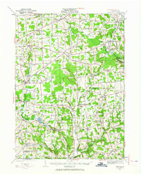
1927 Map of Townville
USGS Topo · Published 1964About this map
Townville serves as a central hub in this rural landscape, which was surveyed during the late 1920s across the border of Crawford and Venango Counties. The region is defined by a dense network of country schools and family-named corners, such as Oregon Cors and Clarks Cors, illustrating a highly localized social structure before the consolidation of rural districts. Along the Pennsylvania railroad line, Tryonville Sta and Centerville stand as important transit points for the local economy. Waterways like Sugar Creek and Muddy Creek wind through the townships, powering small industrial sites like Wilson Mills. For genealogists, the map is particularly valuable for its placement of dozens of specific schoolhouses, including Hatch Sch, Steuben Sch, and the Moss Grove Sch, many of which were the primary landmarks for rural families in the early twentieth century.
Find a feature on this map
101 named features on this map. Tap any name to fly to it.
Don’t see what you’re looking for? This feature index may not catch every label — zoom into the map to look around manually.
Map Details
Editions of this 1927 Townville Map
3 editions found

Other maps of this area

1909 · Franklin
USGS Topo · 1:62,500

1911 · Franklin
USGS Topo · 1:62,500

1911 · Stoneboro
USGS Topo · 1:62,500

1913 · Stoneboro
USGS Topo · 1:62,500

1922 · Oil City
USGS Topo · 1:48,000

1923 · Meadville
USGS Topo · 1:62,500

1923 · Cambridge Springs
USGS Topo · 1:62,500

1924 · Oil City
USGS Topo · 1:62,500

1925 · Meadville
USGS Topo · 1:62,500

1925 · Cambridge Springs
USGS Topo · 1:62,500