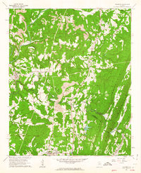
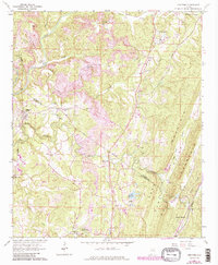
1961 Map of Trafford
USGS Topo · Published 1963About this map
Bradford (Dixiana PO) and Trafford serve as central points of activity in this early 1960s study of the Alabama interior. The landscape is defined by the winding course of the Locust Fork river, where the Deans Ferry Bridge provides a vital crossing point. Industrial signatures are prominent across the terrain, with a large Strip Mine located near Masseyline, illustrating the region's reliance on mineral extraction during this era.
Find a feature on this map
42 named features on this map. Tap any name to fly to it.
Don’t see what you’re looking for? This feature index may not catch every label — zoom into the map to look around manually.
Map Details
Editions of this 1961 Trafford Map
5 editions found
Other maps of this area

1889 · Birmingham
USGS Topo · 1:125,000

1892 · Birmingham
USGS Topo · 1:125,000

1895 · Birmingham
USGS Topo · 1:125,000

1904 · Birmingham Coal District
USGS Topo · 1:62,500

1905 · Leeds
USGS Topo · 1:62,500

1906 · Birmingham Special
USGS Topo · 1:62,500

1907 · Birmingham
USGS Topo · 1:125,000

1907 · Leeds
USGS Topo · 1:62,500

1951 · Warrior
USGS Topo · 1:24,000

1951 · Blount Springs
USGS Topo · 1:24,000