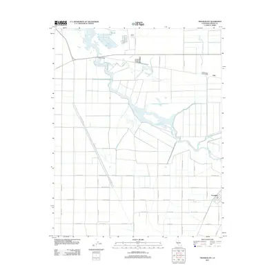
2012 Map of Tranquillity
USGS Topo · Published 2012About this map
Fresno Slough meanders through the heart of this agricultural landscape in Fresno County, defining the drainage patterns of the Central Valley floor. The settlement of Tranquillity anchors the southeastern corner of the sheet, where a concentrated grid of streets meets the open fields. This area is characterized by a precise network of rural roads such as W American Ave and S San Mateo Ave, which divide the land into large-scale farming blocks. Further north, the James Bypass splits from the main slough near Ingle, illustrating the region's managed water systems. Scattered landmarks like Yearout Ranch and the historical Whites Bridge crossing provide specific points of reference for local historians studying the evolution of San Joaquin Valley land use and infrastructure during the early twenty-first century.
Find a feature on this map
29 named features on this map. Tap any name to fly to it.
Don’t see what you’re looking for? This feature index may not catch every label — zoom into the map to look around manually.
Map Details
Editions of this 2012 Tranquillity Map
This is the sole edition of this map. No revisions or reprints were ever made.
Other maps of this area

1921 · Mendota
USGS Topo · 1:31,680

1922 · Tufts Ranch
USGS Topo · 1:31,680

1923 · Levis
USGS Topo · 1:31,680

1923 · Englebrecht Ranch
USGS Topo · 1:31,680

1923 · Firebaugh
USGS Topo · 1:31,680

1924 · Jamesan
USGS Topo · 1:31,680

1924 · Tranquillity
USGS Topo · 1:31,680

1924 · Gravelly Ford
USGS Topo · 1:31,680

1924 · Mendota
USGS Topo · 1:31,680

1925 · San Joaquin
USGS Topo · 1:31,680