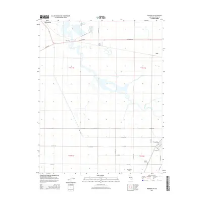
2015 Map of Tranquillity
USGS Topo · Published 2015About this map
The agrarian landscape of the San Joaquin Valley defines this region near the northern edge of the Fresno County agricultural heartland. The city of Mendota sits at the northwestern corner, serving as a gateway to the expansive irrigation and drainage networks that characterize the area. Significant water features like Fresno Slough and the James Bypass thread through the township grids, illustrating the managed hydrography essential to local operations. The settlement of Tranquillity anchors the southeastern portion of the sheet, with a distinct street plan including School Ave and Randolph Ave. Historical transportation routes are prominent, most notably at Whites Bridge and along the Santa Fe - Cord line. Smaller locales such as Ingle are situated along the roadway corridors of W Whitesbridge Rd, marking the steady grid of the Central Valley land system.
Find a feature on this map
29 named features on this map. Tap any name to fly to it.
Don’t see what you’re looking for? This feature index may not catch every label — zoom into the map to look around manually.
Map Details
Editions of this 2015 Tranquillity Map
This is the sole edition of this map. No revisions or reprints were ever made.
Other maps of this area

1921 · Mendota
USGS Topo · 1:31,680

1922 · Tufts Ranch
USGS Topo · 1:31,680

1923 · Levis
USGS Topo · 1:31,680

1923 · Englebrecht Ranch
USGS Topo · 1:31,680

1923 · Firebaugh
USGS Topo · 1:31,680

1924 · Jamesan
USGS Topo · 1:31,680

1924 · Tranquillity
USGS Topo · 1:31,680

1924 · Gravelly Ford
USGS Topo · 1:31,680

1924 · Mendota
USGS Topo · 1:31,680

1925 · San Joaquin
USGS Topo · 1:31,680