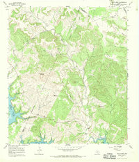
1966 Map of Travis Peak
USGS Topo · Published 1969About this map
Post Oak Ridge and the surrounding Hill Country highlands dominate this 1966 topographic survey where the borders of Travis, Burnet, and Williamson counties converge. The landscape is defined by its deep drainage networks, including Cow Creek and Sulphur Creek, which feed into the northern reaches of Lake Travis. Evidence of the area's mid-century rural character is visible in the network of light-duty and unimproved roads that navigate between prominent peaks such as Boultinghouse Mountain and Bald Mountain.
Find a feature on this map
32 named features on this map. Tap any name to fly to it.
Don’t see what you’re looking for? This feature index may not catch every label — zoom into the map to look around manually.
Map Details
Editions of this 1966 Travis Peak Map
2 editions found
Other maps of this area

1887 · Blanco
USGS Topo · 1:125,000

1887 · Burnet
USGS Topo · 1:125,000

1893 · Georgetown
USGS Topo · 1:125,000

1893 · Burnet
USGS Topo · 1:125,000

1894 · Blanco
USGS Topo · 1:125,000

1896 · Austin
USGS Topo · 1:125,000

1897 · Austin
USGS Topo · 1:125,000

1903 · Burnet
USGS Topo · 1:125,000

1909 · Burnet
USGS Topo · 1:125,000

1910 · Austin
USGS Topo · 1:125,000