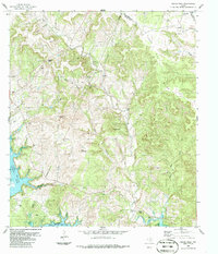
1986 Map of Travis Peak
USGS Topo · Published 1986About this map
Post Oak Ridge dominates the eastern elevation of this Hill Country landscape, looking down over the drainages of Cow Creek and Bee Creek as they wind toward the south. The 1980s terrain is marked by significant topographical variation, including prominent heights like Boultinghouse Mountain and Tater Hill. To the southwest, the Colorado River feeds into Lake Travis, a major hydrological feature that defines the local geography.
Find a feature on this map
34 named features on this map. Tap any name to fly to it.
Don’t see what you’re looking for? This feature index may not catch every label — zoom into the map to look around manually.
Map Details
Editions of this 1986 Travis Peak Map
2 editions found
Other maps of this area

1887 · Blanco
USGS Topo · 1:125,000

1887 · Burnet
USGS Topo · 1:125,000

1893 · Georgetown
USGS Topo · 1:125,000

1893 · Burnet
USGS Topo · 1:125,000

1894 · Blanco
USGS Topo · 1:125,000

1896 · Austin
USGS Topo · 1:125,000

1897 · Austin
USGS Topo · 1:125,000

1903 · Burnet
USGS Topo · 1:125,000

1909 · Burnet
USGS Topo · 1:125,000

1910 · Austin
USGS Topo · 1:125,000