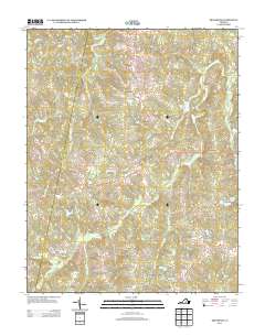
2013 Map of Trenholm
USGS Topo · Published 2013About this map
Trenholm and Ballsville anchor this rural Virginia landscape, which remains defined by a network of creeks and small family-named water bodies. The transition from industrial or large-scale agriculture is evident at sites like Hatchers Dairy Farm and Maxey Mill Cr, while modern residential patterns appear around Hideaway Lake. Small rural clusters such as Hatchers and Smiths Crossroads mark the intersections of long-standing thoroughfares like Cartersville Rd and Trenholm Rd. For genealogists and local historians, the map preserves names tied to the land's hydrology and early settlement, including Bevins Pond, Redford Pond, and several distinctive fishing spots like Bass Pond and Bullhead Pond. The terrain is characterized by the branching drainages of Deep Cr and Muddy Cr, which have historically dictated the placement of roads and homesteads across the county.
Find a feature on this map
57 named features on this map. Tap any name to fly to it.
Don’t see what you’re looking for? This feature index may not catch every label — zoom into the map to look around manually.
Map Details
Editions of this 2013 Trenholm Map
This is the sole edition of this map. No revisions or reprints were ever made.
Other maps of this area

1890 · Goochland
USGS Topo · 1:125,000

1891 · Palmyra
USGS Topo · 1:125,000

1891 · Farmville
USGS Topo · 1:125,000

1892 · Goochland
USGS Topo · 1:125,000

1893 · Farmville
USGS Topo · 1:125,000

1895 · Palmyra
USGS Topo · 1:125,000

1897 · Amelia
USGS Topo · 1:125,000

1897 · Palmyra
USGS Topo · 1:125,000

1943 · Goochland
USGS Topo · 1:31,680

1943 · Powhatan
USGS Topo · 1:31,680