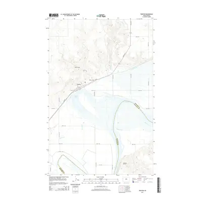
2014 Map of Trenton
USGS Topo · Published 2014About this map
Trenton sits at the northern edge of a wide, shifting river valley where the Missouri River enters the expansive waters of Lake Sakakawea. The landscape is defined by the sharp transition from the level floodplains to the dissected uplands of Williams County, carved by drainage features like Miller Coulee and Bobs Coulee. The town's layout follows the trajectory of ND-1804 and the adjacent rail corridor, emphasizing the importance of this transportation spine in the northern Great Plains. South of the settlement, the hydrology is complex, with the oxbow of Lake Trenton and the confluence of several tributaries including Eightmile Cr and Painted Woods Cr. In the southeast, the terrain rises toward Crow Fly High Hill, overlooking the boundary between Williams and McKenzie counties. This 2014 survey documents the modern configuration of the reservoir shoreline and the grid of rural roads that connect these isolated high-plains communities.
Find a feature on this map
31 named features on this map. Tap any name to fly to it.
Don’t see what you’re looking for? This feature index may not catch every label — zoom into the map to look around manually.
Map Details
Editions of this 2014 Trenton Map
This is the sole edition of this map. No revisions or reprints were ever made.
Other maps of this area

1953 · Williston
USGS Topo · 1:250,000

1953 · Watford City
USGS Topo · 1:250,000

1957 · Williston
USGS Topo · 1:250,000

1957 · Watford City
USGS Topo · 1:250,000

1959 · Williston West
USGS Topo · 1:24,000

1967 · Watford City
USGS Topo · 1:250,000

1968 · Trenton SW
USGS Topo · 1:24,000
1968 · Buford
USGS Topo · 1:24,000

1969 · Trenton
USGS Topo · 1:24,000

1969 · Cartwright NE
USGS Topo · 1:24,000