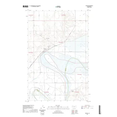
2020 Map of Trenton
USGS Topo · Published 2020About this map
Trenton sits near the northern bank of the Missouri River, serving as a focal point for the surrounding rural landscape in Williams County. This modern survey illustrates the complex relationship between the high prairie and the river bottomlands, with the settlement positioned where the bluffs descend into the valley near Bobs Coulee. Local history is anchored by the Trenton Cem, located just north of the town center. The topography is defined by significant drainage systems, including Eightmile Cr and Sixmile Creek, which carve through the terrain. To the southeast, the prominent Crow Fly High Hill rises above the valley floor, marking a significant geographic landmark within the Missouri River's shifting floodplains and wetland areas.
Find a feature on this map
33 named features on this map. Tap any name to fly to it.
Don’t see what you’re looking for? This feature index may not catch every label — zoom into the map to look around manually.
Map Details
Editions of this 2020 Trenton Map
This is the sole edition of this map. No revisions or reprints were ever made.
Other maps of this area

1953 · Williston
USGS Topo · 1:250,000

1953 · Watford City
USGS Topo · 1:250,000

1957 · Williston
USGS Topo · 1:250,000

1957 · Watford City
USGS Topo · 1:250,000

1959 · Williston West
USGS Topo · 1:24,000

1967 · Watford City
USGS Topo · 1:250,000

1968 · Trenton SW
USGS Topo · 1:24,000
1968 · Buford
USGS Topo · 1:24,000

1969 · Trenton
USGS Topo · 1:24,000

1969 · Cartwright NE
USGS Topo · 1:24,000