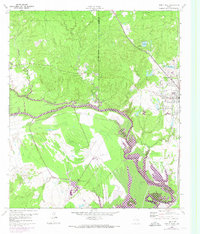
1960 Map of Trinity West
USGS Topo · Published 1974About this map
The Trinity River serves as the winding centerpiece of this landscape, marking the natural boundary between Walker and Trinity Counties. In the early 1960s, the development of Lake Livingston began to transform the river valley, with purple photorevisions from 1972 showing the extent of controlled inundation along the shorelines. The town of Trinity sits at a critical junction of the Missouri Pacific and the Waco Beaumont Trinity and Sabine railroads, reflecting a period when rail transport still defined the local economy and timber industry near Mill Pond. South of the river, the institutional presence of Smither Prison Farm and Smither Farm dominates the terrain, while the local community is anchored by landmarks like Mt Olive. Numerous smaller water bodies like Lake Jennifer and Sentell Lake dot the hills, illustrating the managed water resources of East Texas during this era of infrastructure growth.
Find a feature on this map
22 named features on this map. Tap any name to fly to it.
Don’t see what you’re looking for? This feature index may not catch every label — zoom into the map to look around manually.
Map Details
Editions of this 1960 Trinity West Map
3 editions found
Other maps of this area

1953 · Palestine
USGS Topo · 1:250,000

1954 · Beaumont
USGS Topo · 1:250,000

1957 · Beaumont
USGS Topo · 1:250,000

1957 · Palestine
USGS Topo · 1:250,000

1960 · Trinity West
USGS Topo · 1:24,000

1960 · Trinity East
USGS Topo · 1:24,000

1961 · Staley
USGS Topo · 1:24,000

1961 · Riverside
USGS Topo · 1:24,000

1962 · Pine Prairie
USGS Topo · 1:24,000

1962 · Lovelady South
USGS Topo · 1:24,000