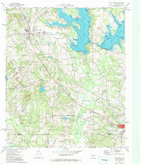
1973 Map of Troup West
USGS Topo · Published 1976About this map
The transition between Whitehouse and Troup is defined by the expansive waters of Lake Tyler East and its intricate shoreline of coves and peninsulas. At this time in the early 1970s, the landscape south of Blackhawk reveals a mix of rural community centers and emerging infrastructure, including a Drag Strip and a Rodeo Ground. Local heritage is anchored by several country churches such as Walnut Grove Ch and New Canaan Ch, while the Missouri Pacific railroad cuts a diagonal line toward the southeast corner of the map. Along the Smith Co Cherokee Co line, the terrain drops toward Mud Creek, where small-scale extraction is evidenced by scattered Oil Wells and a Drill Hole. This survey captures the region just as the recreational potential of the reservoir began to reshape the older agricultural and rail-oriented settlement patterns of eastern Texas.
Find a feature on this map
73 named features on this map. Tap any name to fly to it.
Don’t see what you’re looking for? This feature index may not catch every label — zoom into the map to look around manually.
Map Details
Editions of this 1973 Troup West Map
2 editions found
Other maps of this area

1937 · Troupe
USGS Topo · 1:48,000

1938 · Winona
USGS Topo · 1:48,000

1943 · Troup
USGS Topo · 1:62,500

1943 · Winona
USGS Topo · 1:62,500

1946 · Bullard
USGS Topo · 1:62,500

1948 · Bullard
USGS Topo · 1:62,500

1948 · Tyler
USGS Topo · 1:62,500

1949 · Tyler
USGS Topo · 1:62,500

1956 · Tyler
USGS Topo · 1:250,000

1966 · Hope Pond
USGS Topo · 1:24,000