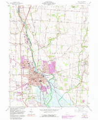
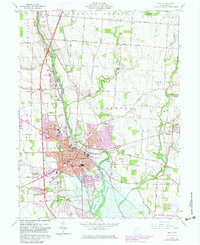
1961 Map of Troy
USGS Topo · Published 1991About this map
The Great Miami River anchors this landscape, flowing past the manufacturing and commercial center of Troy. This survey, updated with purple-tinted aerial revisions in the early 1980s, captures a pivotal period of suburban expansion into the surrounding farmlands of Staunton and Concord townships. The map documents an extensive network of local institutions, from the Miami County Fairground and Treasure Island Park to historic public schools such as Heywood Sch and Van Cleve Sch. Industrial activity is evident in the Quarry and Gravel Pits north of town, while the Baltimore and Ohio railroad corridor highlights the enduring importance of rail transport to the local economy. Genealogists will find a high density of burial sites including Riverside Cemetery, Rose Hill Cem, and numerous smaller family or community plots like Saunders Cem and Thomas Cem, many located near the banks of Spring Creek and Lost Creek.
Find a feature on this map
55 named features on this map. Tap any name to fly to it.
Don’t see what you’re looking for? This feature index may not catch every label — zoom into the map to look around manually.
Map Details
Editions of this 1961 Troy Map
5 editions found
Other maps of this area

1904 · Dayton
USGS Topo · 1:62,500

1905 · Brookville
USGS Topo · 1:62,500

1906 · Dayton
USGS Topo · 1:62,500

1911 · Covington
USGS Topo · 1:62,500

1914 · Troy
USGS Topo · 1:62,500

1944 · Covington
USGS Topo · 1:62,500

1944 · Troy
USGS Topo · 1:62,500

1953 · Cincinnati
USGS Topo · 1:250,000

1953 · Muncie
USGS Topo · 1:250,000

1955 · West Milton
USGS Topo · 1:24,000