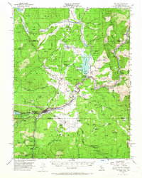
1955 Map of Truckee
USGS Topo · Published 1965About this map
Truckee serves as the central hub of this mid-century survey, situated at the confluence of the Truckee River and the Southern Pacific railroad line. The landscape reveals an era of transition for the High Sierra, where timber and water management are the primary industrial drivers. To the north, Hobart Mills and several former mill locations like Old Schaeffer Mill (Site) indicate the region's logging heritage, while the presence of the Boca Reservoir and the Boca Dam reflect evolving water infrastructure. The eastern edge captures the transit corridor along the canyon, following the river through Hirschdale toward Floriston and Mystic at the Nevada border. Notable landmarks such as the Truckee Airport, Donner Memorial State Park, and the Joerger Ranch in Martis Valley provide specific points of interest for local historians and genealogists tracking the development of these mountain communities.
Find a feature on this map
94 named features on this map. Tap any name to fly to it.
Don’t see what you’re looking for? This feature index may not catch every label — zoom into the map to look around manually.
Map Details
Editions of this 1955 Truckee Map
4 editions found
Other maps of this area

1890 · Sierraville
USGS Topo · 1:125,000

1891 · Carson
USGS Topo · 1:125,000

1891 · Truckee
USGS Topo · 1:125,000

1891 · Reno
USGS Topo · 1:125,000

1892 · Sierraville
USGS Topo · 1:125,000

1893 · Carson
USGS Topo · 1:125,000

1893 · Truckee
USGS Topo · 1:125,000

1893 · Reno
USGS Topo · 1:125,000

1894 · Sierraville
USGS Topo · 1:125,000

1895 · Truckee
USGS Topo · 1:125,000