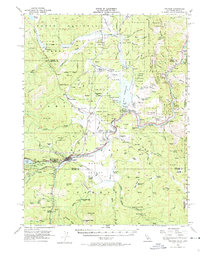
1955 Map of Truckee
USGS Topo · Published 1974About this map
Truckee stands as the central hub of this mid-century survey, situated at the confluence of the Truckee River and Martis Creek just east of Donner Lake. The map captures a mountain landscape defined by early industrial and timber operations, featuring prominent historical locations such as Union Mills (Site) and the Old Schaeffer Mill (Site). Further north, the lumber town of Hobart Mills is shown alongside the Hobart Reservoir, while the Southern Pacific railroad follows the river's winding path toward the Nevada border. Along this rail corridor, small settlements and sidings like Boca, Hirschdale, and Floriston mark the canyon's edge. The presence of the Truckee Airport and the Airway Beacon on Alder Hill illustrates the area's role in early transcontinental aviation, while landmarks like Donner Memorial State Park preserve the memory of the region's pioneering history.
Find a feature on this map
83 named features on this map. Tap any name to fly to it.
Don’t see what you’re looking for? This feature index may not catch every label — zoom into the map to look around manually.
Map Details
Editions of this 1955 Truckee Map
4 editions found
Other maps of this area

1890 · Sierraville
USGS Topo · 1:125,000

1891 · Carson
USGS Topo · 1:125,000

1891 · Truckee
USGS Topo · 1:125,000

1891 · Reno
USGS Topo · 1:125,000

1892 · Sierraville
USGS Topo · 1:125,000

1893 · Carson
USGS Topo · 1:125,000

1893 · Truckee
USGS Topo · 1:125,000

1893 · Reno
USGS Topo · 1:125,000

1894 · Sierraville
USGS Topo · 1:125,000

1895 · Truckee
USGS Topo · 1:125,000