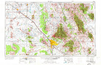
1956 Map of Tucson
USGS Topo · Published 1973About this map
The Santa Cruz River valley serves as the central corridor for this 1950s-era landscape, where the growing city of Tucson is bounded by the Santa Catalina Mountains and the Saguaro National Monument. This survey reveals a region transitioning from its deep indigenous and colonial roots, represented by the San Xavier del Bac Mission and several tribal villages like Tat Momoli, toward a modern era of military and industrial expansion. The presence of the Davis-Monthan Air Force Base and the Sahuarita Bombing And Gunnery Range highlights the Cold War-era strategic importance of the Arizona desert.
Find a feature on this map
123 named features on this map. Tap any name to fly to it.
Don’t see what you’re looking for? This feature index may not catch every label — zoom into the map to look around manually.
Map Details
Editions of this 1956 Tucson Map
3 editions found

Other maps of this area

1900 · Florence
USGS Topo · 1:125,000

1902 · Florence
USGS Topo · 1:125,000

1904 · Patagonia
USGS Topo · 1:125,000

1904 · Tucson
USGS Topo · 1:125,000

1905 · Patagonia
USGS Topo · 1:125,000

1905 · Tucson
USGS Topo · 1:125,000

1907 · Sacaton
USGS Topo · 1:62,500

1910 · Ray
USGS Topo · 1:62,500

1911 · Winkelman
USGS Topo · 1:125,000

1913 · Winkelman
USGS Topo · 1:125,000