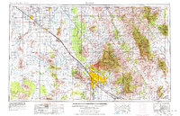
1956 Map of Tucson
USGS Topo · Published 1978About this map
Tucson dominates the central valley floor in this mid-century portrait of southern Arizona, where the burgeoning desert city is bordered by the Santa Catalina Mountains and the sprawling Saguaro National Monument. The landscape is a study in 1950s infrastructure and industrial expansion, from the heavy copper operations at the San Manuel Mine to the bustling corridors of the Southern Pacific railroad and U S 80. To the north and west, the agricultural geometry of the Santa Cruz Flats near Eloy and Cesa Grande contrasts sharply with the vast tribal lands of the Papago Indian Reservation.
Find a feature on this map
72 named features on this map. Tap any name to fly to it.
Don’t see what you’re looking for? This feature index may not catch every label — zoom into the map to look around manually.
Map Details
Editions of this 1956 Tucson Map
3 editions found

Other maps of this area

1900 · Florence
USGS Topo · 1:125,000

1902 · Florence
USGS Topo · 1:125,000

1904 · Patagonia
USGS Topo · 1:125,000

1904 · Tucson
USGS Topo · 1:125,000

1905 · Patagonia
USGS Topo · 1:125,000

1905 · Tucson
USGS Topo · 1:125,000

1907 · Sacaton
USGS Topo · 1:62,500

1910 · Ray
USGS Topo · 1:62,500

1911 · Winkelman
USGS Topo · 1:125,000

1913 · Winkelman
USGS Topo · 1:125,000