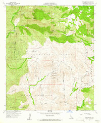
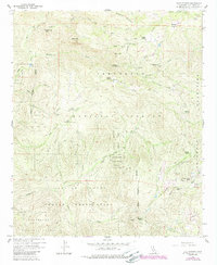
1960 Map of Tule Springs
USGS Topo · Published 1961About this map
Capitan Grande Indian Reservation dominates the southern landscape of this 1960 survey, where the King Creek and Conejos Creek canyons converge. The geography is defined by the sharp transition from the Cuyamaca Mountains in the east to the deep drainage of the San Diego River in the northwest. Scattered ranching outposts such as Rancho Alegria, Burney Ranch, and Echo Dell Ranch suggest a sparse, resource-driven settlement pattern common in this part of San Diego County during the mid-century.
Find a feature on this map
39 named features on this map. Tap any name to fly to it.
Don’t see what you’re looking for? This feature index may not catch every label — zoom into the map to look around manually.
Map Details
Editions of this 1960 Tule Springs Map
5 editions found
Other maps of this area

1893 · El Cajon
USGS Topo · 1:62,500

1901 · Elcajon
USGS Topo · 1:62,500

1903 · Cuyamaca
USGS Topo · 1:125,000

1903 · Elcajon
USGS Topo · 1:62,500

1903 · Ramona
USGS Topo · 1:125,000

1904 · Southern California Sheet No. 2
USGS Topo · 1:250,000

1939 · El Cajon
USGS Topo · 1:62,500

1939 · Santa Ysabel
USGS Topo · 1:62,500

1942 · El Cajon
USGS Topo · 1:62,500

1942 · Ramona
USGS Topo · 1:62,500