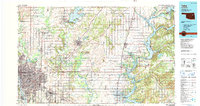
1985 Map of Tulsa
USGS Topo · Published 1990About this map
The Arkansas River corridor serves as the anchor for this mid-1980s landscape, where the expanding urban reach of Tulsa and Broken Arrow meets a complex network of waterways and industrial infrastructure. The map illustrates a mature petroleum and transportation hub, marked by extensive Oil Field notations and major transit arteries like the Will Rogers Turnpike. Beyond the urban centers, the landscape is defined by the massive reservoirs of Oologah Lake, Lake Hudson, and Fort Gibson Lake, which transformed the hydrology of the Verdigris and Neosho rivers.
Find a feature on this map
99 named features on this map. Tap any name to fly to it.
Don’t see what you’re looking for? This feature index may not catch every label — zoom into the map to look around manually.
Map Details
Editions of this 1985 Tulsa Map
2 editions found
Other maps of this area

1896 · Okmulgee
USGS Topo · 1:125,000

1896 · Pryor
USGS Topo · 1:125,000

1898 · Tahlequah
USGS Topo · 1:125,000

1899 · Siloam Springs
USGS Topo · 1:125,000

1900 · Okmulgee
USGS Topo · 1:125,000

1901 · Muscogee
USGS Topo · 1:125,000

1901 · Claremore
USGS Topo · 1:125,000

1901 · Nowata
USGS Topo · 1:125,000

1901 · Vinita
USGS Topo · 1:125,000

1901 · Pryor
USGS Topo · 1:125,000