
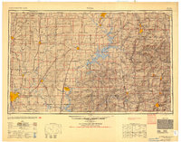
1954 Map of Tulsa
USGS Topo · Published 1954About this map
The Tri-State Mining District dominates the northeast corner of this mid-century survey, illustrating the lead and zinc industry centering around Picher and Miami. To the west, the growing urban footprint of Tulsa is flanked by industrial sites like the Oklahoma Ordnance Works, a sprawling World War II-era manufacturing complex near Pryor. The region's transition into a recreational and hydroelectric hub is evident through major water projects like Grand Lake O' The Cherokees and Lake Spavinaw, which reshaped the terrain of the Ozark Plateau and Spavinaw Hills.
Find a feature on this map
276 named features on this map. Tap any name to fly to it.
Don’t see what you’re looking for? This feature index may not catch every label — zoom into the map to look around manually.
Map Details
Editions of this 1954 Tulsa Map
2 editions found
Other maps of this area

1885 · Sedan
USGS Topo · 1:125,000

1886 · Joplin
USGS Topo · 1:125,000

1886 · Greenfield
USGS Topo · 1:125,000

1886 · Independence
USGS Topo · 1:125,000

1886 · Carthage
USGS Topo · 1:125,000

1886 · Parsons
USGS Topo · 1:125,000

1888 · Greenfield
USGS Topo · 1:125,000

1889 · Sedan
USGS Topo · 1:125,000

1893 · Parsons
USGS Topo · 1:125,000

1894 · Independence
USGS Topo · 1:125,000